OpenLandMap.org is a data portal to the world’s environmental data representing land mask (land cover, vegetation, soil, climate, terrain data and similar). OpenLandMap.org is OpenGeoHub’s central place for global datasets covering land mask. If not specified otherwise, OpenLandMap layers are open data, licensed under the Open Data Commons Open Database License (ODbL) and/or Creative Commons Attribution-ShareAlike 4.0 International license (CC BY-SA) by the OpenGeoHub Foundation.
You are free to copy, distribute, transmit and adapt our data, as long as you credit OpenLandMap.org and its contributors. If you alter, or build upon, our data, you may distribute the result only under the same licence. The full legal code explains your rights and responsibilities.
If not otherwise specified, the cartography in our map tiles, and our documentation, are licensed under the Creative Commons Attribution-ShareAlike 4.0 International license (CC BY-SA).
Components
![]()
The OpenLandMap.org system consists of the three main components:
1. The data: a stack of relevant gridded global environmental layers available as raw data (currently via Zenodo.org), through Web Mapping Service (WMS) and through REST API. The data component includes:
- OpenLandMap basic layers = produced internally by our development team,
- OpenLandMap layers contributed by others,
- Input training point data, additional vector layers and background maps (e.g. OpenTopoMap),
2. The web-services: user-friendly websites, apps (Web-GIS) and STAC to facilitate discovery, visualization, review and download of all data. Web-services include:
- Web-mapping App = provided at https://openlandmap.org
- OGC WMS, WCS facilities,
- STAC = SpatioTemporal Asset Catalogs provided at https://stac.openlandmap.org,
3. The organization: i.e. the developers, users and developers’ communities (discussion groups, workshops and tutorials). These are linked and managed through the OpenGeoHub.org website and social networks. The most active groups of developers include:
- The OpenLandMap maps development team = maintains basic layers and produces new layers,
- The OpenLandMap web development team = maintains basic functionality and the web services,
- The OpenLandMap review committee = reviews all newly submitted layers and approves or rejects applications (reports to the OpenGeoHub Scientific committee),
- The OpenLandMap contributors = contributing organizations and/or individuals,
Themes of interest
The data component of OpenLandMap represents several environmental thematic fields, that mainly describe topography, vegetation, soil properties and classes, geology, hydrology, land cover, land use and landscape metrics in general (see below). For practical purposes, we have organized the monitoring networks and data sets around the following themes UN-GGIM The Global Fundamental Geospatial Data Themes:
- Buildings and Settlements,
- Elevation and Depth,
- Geology and Soils,
- Land Cover and Land Use,
- Population Distribution,
- Water,
- Physical Infrastructure,
- Climate,
- Biodiversity and Nature Conservation,
Download data
To download raw data (GeoTIFFs) please use links under “Download data” inside the OpenLandMap.org app, which point to the unique DOI generated through Zenodo.org. Learn more about how to search and download files from Zenodo at: https://help.zenodo.org/. To access Zenodo data we advise using the curl functionality of Zenodo.
You can also download smaller subsets of data or use gdalwarp functionality directly by using the opengeohub servers.
To access OpenLandMap layers using the OpenLandMap API please refer to this tutorial.
Why OpenLandMap?
The value of data is in its use. Data sets tend to be widely used if they are relevant, easy to discover and obtain, free or nearly free, offer complete and comprehensive regional to global coverage, are current (high temporal frequency and frequently updated) and are of as high a quality (as correct) as possible. In addition to this, users develop trust in data if the procedures used to generate it are transparent and well documented. Good decision making requires relevant, current and trusted data.
We believe that the key to making quality data, that has a potential to influence decision making, is in making data Open. Open meaning easily accessible without bureaucratic obstacles (i.e. data registered under an Open Database License), well documented (up to the level of full reproducibility), and available through simple, inexpensive but diverse OGC web-services (Geoserver and Geonetwork).
Over the years we have observed that there is a vast amount of legacy data on land already publicly available, including observations of land cover, land use, soil properties and qualities, that is systematically under-used but nonetheless provides a lot of value. We have therefore decided to try to integrate, harmonize and process this underused data using state-of-the-art Machine Learning algorithms and to extract valuable information patterns and trends, not immediately recognizable from ground observations and remote sensing data itself. We have further chosen to automate this process and to open it to all interested users, so that we can further accelerate use and empower users to create their own, new Open data (read more about the OpenGeoHub projects).
The main objectives of OpenLandMap are:
- To serve as an international reference for global planning and assessment projects (reference data sets and standards).
- To facilitate easy access to, and use of, environmental layers potentially important for spatial modelling, decision making and for raising public awareness about land degradation, land restoration and land potential.
- To provide a platform where freely available global datasets of interest to spatial modellers at local, regional and global scales can be widely shared, continuously improved and regularly expanded.
- To promote use of automated mapping (especially based on Machine Learning implemented using Open Source software) for generating the highest possible quality of Open environmental data.
- To save the planet! We genuinely aspire to support global to local land restoration and nature conservation projects with Open, high quality data.
OpenLandMap aims to directly support international initiatives and organizations by serving up the highest quality environmental data. Examples include:
Types of maps published
If you would like to host your data on OpenLandMap, please submit an application by following these instructions.
The main types of maps to be published on the OpenLandMap data portal include:
- PP (v0.-): any map attached to a submitted publication i.e. only a pre-print of the documentation is available. This requires that at least all the processing steps have been documented and are available.
- PR (v1.-): any map attached to a publication that has been either accepted for publication or is already published. First version available online after acceptance of the work.
- HT (>=v1.-): stable maps well documented where regular updates are also optional.
Technical assessment of the type of map is done by the Reviewing Committee. Codes are automatically updated (status upgraded) based on (1) e.g. DOI of the publication becoming available, and (2) web-traffic achieving a certain minimum threshold.
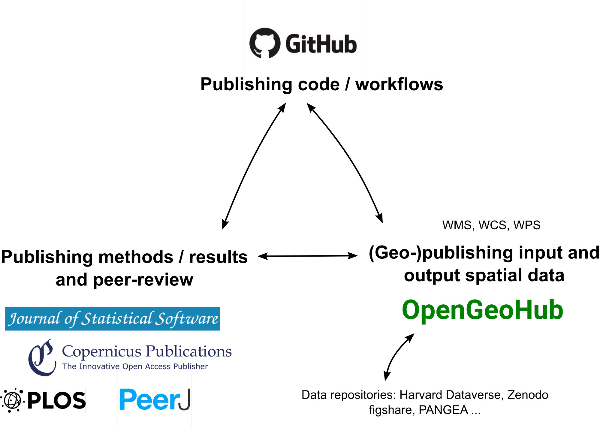
OpenGeoHub supports Open Science: (a) develop procedures and collect feedback using Github, (b) publish documentation with Open Access publishers such as PLOS, Copernicus Publications and PeerJ, and (c) publish the corresponding data using OGC standards vis GeoServer.
Data sources (credits)
OpenLandMap is largely inspired and based on other Open Data projects including: UMD GLAD, MODIS land products, OpenStreetMap.org, GBIF.org, GlobalForestWatch.org, Geo-wiki.org, Protectedplanet.net, EarthEnv.org, SoilGrids.org and similar.
The most important remote sensing data sources used to generate OpenLandMap layers include: ESA Climate Change Initiative (Land Cover led by UCLouvain) global layers, Copernicus PROB-V land products, NASA’s MODIS and Landsat projects, USGS Global Ecophysiography project, Food and Agriculture Organization (FAO) of the United Nations global mapping projects, NOAA Earth Observation Group (EOG) global layers, Africa Soil Information Service (AfSIS project, funded by the Bill and Melinda Gates foundation) data, PBL Netherlands Environmental Assessment Agency databases of the Global Environment, European Commission Joint Research Centre (JRC) data, The Nature Conservancy data products, NASA’s Global Precipitation Measurement Integrated Multi-satellitE Retrievals for GPM (IMERG), JAXA ALOS project data sets, University of Maryland Global Land Cover Facility data, Greenpeace, World Resources Institute, and many others.
OpenLandMap App is based on open-source software: Geoserver, Geonode, React, plumber R and OpenLayers.
Background layers:
- OpenStreetMap © OpenStreetMap contributors;
- OpenTopoMap cartography © OpenTopoMap;
- BingMaps Aerial © 2018 Microsoft;
- Stamen maps © Stamen Design;
We are grateful to all organisations that provided input data used to create OpenLandMap layers. We are also grateful to EnvirometriX Ltd, Wageningen, and GILab D.O.O for developing front-end / back-end solutions in support of the OpenLandMap project. We are also grateful to Spatial Ecology and Margosa Environmental Solutions for contributing global layers of DEM derivatives and hydrological parameters.
Every effort has been made to trace copyright holders of the materials used to produce OpenLandMap layers. Should we, despite all our best efforts, have overlooked contributors please contact the OpenGeoHub Foundation and we will correct this unintentional omission without delay and will acknowledge any overlooked contributions and recognize new contributors in future updates.
Funding
OpenLandMap is a generic platform for publishing and exposing global environmental data sets. Its development is possible thanks to multiple funding sources listed below.
Global Pasture Watch is part of the Land Carbon Lab project lead by WRI.
Open-Earth-Monitor Cyberinfrastructure project (2023-2027) gathers 21 research organization.
“The Open-Earth-Monitor Cyberinfrastructure project has received funding from the European Union’s Horizon Europe research and innovation programme under grant agreement No. 101059548.
How accurate and reliable are OpenLandMap maps?
No map is 100% perfect. All of the layers distributed via https://openlandmap.org can still be improved in terms of accuracy, spatial detail, obvious artifacts, completeness and similar. Identifiable errors in some of our initial products are expected to provoke responses and stimulate feedback. We plan to produce continuous updates and improvements, so user feedback is therefore crucial. To learn more about the accuracy of the maps provided please refer to metadata available and/or to documentation for each layer of interest. If you discover an issue or a bug, please make sure you report it.
How to contribute?
Help us continuously improve these maps by:
- submitting detailed comments and suggestions via https://github.com/openlandmap/,
- helping this community project by joining one, or more, of the OpenGeoHub Working Groups,
- contributing relevant training data such as field observations or laboratory analysis data for modelling soil, vegetation, parent material or similar subject areas,
We also collect donations (which are used exclusively for maintaining the system and providing scholarships for students).
If you are currently producing any similar types of data (e.g. environmental layers at resolutions from 30 m to 1 km for a global land mask) and if you would like to publish this data on OpenLandMap, please forward a proposal for publishing your global layers:
- provide a technical description of the layers, approximate size after compression, data license and similar,
- provide links to documentation and tutorials explaining how the data were generated,
As a general consideration OpenGeoHub requires that any data to be published via OpenLandMap satisfies some minimum quality and metadata requirements before it can be accepted to be hosted via our service (read more).
The Open Data review process includes:
- Technical checking of the data documentation and completeness (usually we run a script on your data that does all checks).
- Checking of data licenses (an Open data license is required).
- Checking of workflows — especially important if scientific publication is not available or still in review.
- Optimization of file size and compression.
- Visual checking of any artifacts in maps, land and water masks and similar.
OpenGeoHub however will not interfere with the peer-review process or evaluate the methodological validity of produced maps.
The OpenLandMap Review Committee evaluates submitted applications for hosting at OpenGeoHub and then, depending on the decision, will recommend publication of the maps on the OpenLandMap portal or suggest revisions. Since hosting of large maps (>50GB per submission) can be time-consuming and can result in high hosting and processing costs, users are also encourage to make use of commercial options provided by third parties (maps discoverable and visible via OpenLandMap.org, but hosted through a different system).
Types of maps that will not be considered:
- Incomplete, undocumented and not strictly following all submission instructions,
- Proprietary maps or maps distributed under the non-Open / restrictive Non-Commercial licenses,
- Previously copyrighted materials that can not be put under one or more of the recognized Open Data licenses,
- Containing false information or serious flaws,
How to credit OpenLandMap
We require that you credit each layer based on the instructions available in the metadata or on the landing page. If no other option is available you can credit these data by using “© OpenLandMap.org contributors” and/or by using https://openlandmap.org.
You must also make it clear that the data are available under the Open Data Commons Open Database License (ODbL) and/or Creative Commons Attribution-ShareAlike 4.0 International license (CC BY-SA), and if using our map tiles, that the cartography is licensed as CC BY-SA. You may do this by linking to our copyright page. Alternatively, and as a requirement if you are distributing OpenLandMap in a data form, you can name and link directly to the license(s). In media where links are not possible (e.g. printed works), we suggest you direct your readers to https://openlandmap.org, and if relevant, to the opengeohub.org foundation homepage.
Copyright infringement
OpenGeoHub contributors are reminded never to add data from any copyrighted sources (e.g. Google Maps or printed maps) without explicit permission from the copyright holders. If you believe that copyrighted material has been inappropriately added to the OpenLandMap database or this site, please contact us.
OpenGeoHub and OpenLandMap are registered trademarks of the OpenGeoHub Foundation.